|
<< Click to Display Table of Contents >> Project Info Tab |
  
|
|
<< Click to Display Table of Contents >> Project Info Tab |
|
The Project Info tab is used to specify the project's information and extents.
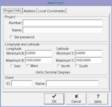
The following information can be specified on this tab:
Project Number: This is the unique project number.
Project Name: This is the name of the project.
Longitude Minimum X: This is the left boundary of the project in map units, normally it is the minimum longitude.
Longitude Maximum X: This is the right boundary of the project in map units, normally it is the maximum longitude.
East: Check this if the project is in the eastern hemisphere.
West: Check this if the project is in the western hemisphere.
Latitude Minimum Y: This is the lower boundary of the project in map units, normally it is the minimum latitude.
Latitude Maximum Y: This is the upper boundary of the project in map units, normally it is the maximum latitude.
North: Check if the project is in the northern hemisphere.
South: Check if the project is in the southern hemisphere.Client ID: This is an optional client identification.
Client ID: This is an optional client identification.
Client Name: This an optional client name.