|
<< Click to Display Table of Contents >> Editing a Water Level |
  
|
|
<< Click to Display Table of Contents >> Editing a Water Level |
|
The points on a water level can be edited by selecting the water level by clicking on it or clicking on it on the sidebar. Marquee boxes will then be drawn around the points of the water level. These points can be moved by clicking on them and dragging them to their new location.
Water levels can also be edited by:
•clicking on them on the sidebar
•selecting Edit > Water Levels > Water Level number or Popup > Water Levels > Water Level number
•double clicking on the water level
The Water Level Information form will be displayed.
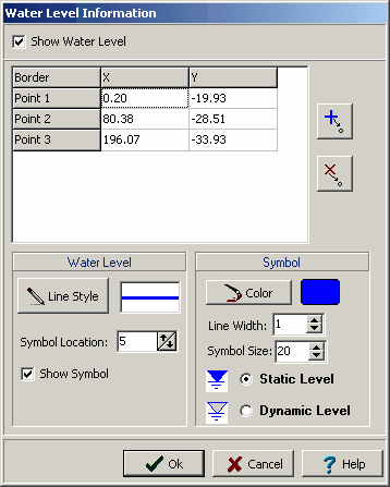
The following information can be entered and edited using this form:
Show Water Level: Check to show this water level on the cross-section.
The water level is composed of a series of line segments between points.
Point X: This is the horizontal position of the points.
Point Y: This is the vertical position of the points.
![]() The Add Point button is used to add a point to the water level.
The Add Point button is used to add a point to the water level.
![]() The Delete Point button is used to delete a point on the water level.
The Delete Point button is used to delete a point on the water level.
Line Style: This is the style of the water level. The line style can be changed by pressing the Line Style button.
Symbol Location: This is the location of the water level symbol on the polyline. It is expressed as a percentage of the distance from left to right of the cross-section. So that 25% would put the symbol one quarter from the left side of the cross-section.
Show Symbol: Check to display the water level symbol.
Symbol Color: This is the color of the water level symbol. Press the color button to change the color.
Symbol Line Width: This is the width of the line used to draw the water level symbol.
Symbol Size: This is the relative size of the water level symbol.
Symbol Type: This selects whether to draw the symbol as a static water level (shaded triangle) or dynamic water level (hollow triangle).