|
<< Click to Display Table of Contents >> Information Tab |
  
|
|
<< Click to Display Table of Contents >> Information Tab |
|
The Information tab is used to specify the general information for the sample.
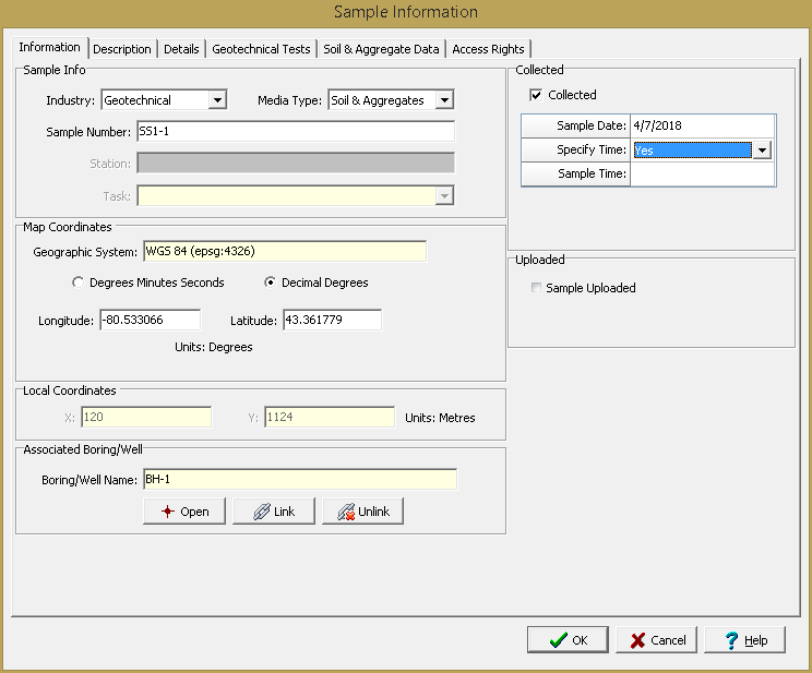
The following information can be specified on this tab:
Sample Info
Industry: This is used to select the whether the sample is for environmental tests, geotechnical tests, or both.
Media Type: This is used to select the media type for the sample. The Media Data tab will be different for each media type selected
Station: If the sample is associated with a station, the station will be shown. This can not be edited.
Task: If the sample is associated with a task, the task will be shown. This can not be edited.
Map Coordinates
If it is a local project the following are not displayed.
Coordinate System: This is the coordinate system specified when the project is created. It can be either a geographic or projected coordinate system. The default is the WGS 1984 geographic coordinate system used internally by the program to store location data.
Degrees Minutes Seconds or Decimal Degrees: If the coordinate system is geographic, this can be used to display the coordinates in either degrees, minutes, and seconds or decimal degrees.
Longitude: For a geographic coordinate system this is the longitude in either degrees, minutes, and seconds or decimal degrees.
Latitude: For a geographic coordinate system this is the latitude in either degrees, minutes, and seconds or decimal degrees.
Easting: For a projected coordinate system this is the x coordinate in map units.
Northing: For a projected coordinate system this is the y coordinate in map units.
Local Coordinates
Local X-Coordinate: This is the x coordinate in local units. If the project is georeferenced the local coordinates are calculated automatically.
Local Y-Coordinate: This is the y coordinate in local units. If the project is georeferenced the local coordinates are calculated automatically
Associated Boring/Well
Boring/Well Name: If the station is associated with a boring or well, it can be linked to the station. If a boring or well has been linked to the station it can be opened in the WinLoG module by clicking on the Open button.
Collected
Collected: This should be checked if the sample has been collected.
Sample Date: If the sample is not continuous and has been collected, this is used to select the collection date.
Start Date: If the sample is continuous and has been collected, this is used to select the start date.
End Date: If the sample is continuous and has been collected, this is used to select the end date.
Specify Time: If the sample has been collected, this is used to indicate whether the time of collection should be specified.
Sample Time: If the time of collection is being specified and the sample is not continuous this is used to select the time.
End Time: If the time of collection is being specified and the sample is continuous this is used to select the time.
Sample Time: If the time of collection is being specified and the sample is continuous this is used to select the time.
Uploaded
Sample Uploaded: If the sample was uploaded from EDMS Field this will be checked. This can not be edited.
Date Uploaded: If the sample was uploaded, this displays the date it was uploaded from EDMS Field.