|
<< Click to Display Table of Contents >> Creating a New Dataset |
  
|
|
<< Click to Display Table of Contents >> Creating a New Dataset |
|
To create a new dataset, select Edit > Other Datasets > New. The New Dataset form will be displayed. This form has two tabs one for entering the dataset information and the other to list the existing other datasets in the project.
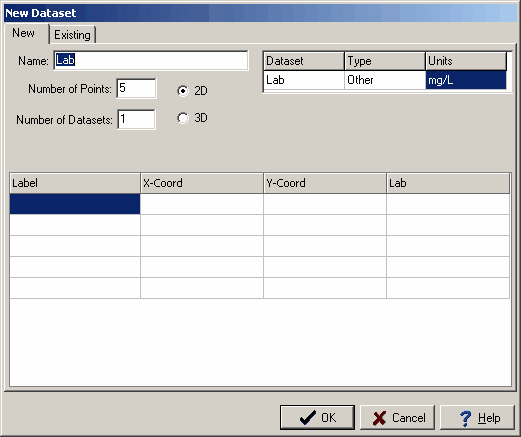
The following information can be entered on the New tab:
Name: This is the unique name of the dataset. Existing datasets are listed in the next tab.
Number of Points: This is the number of data points in the dataset.
Number of Datasets. This is the number of datasets. The data can consist of more than one dataset. All of the datasets will have the same x and y coordinates, but can have different values at those coordinates. For example, the datasets could be used to store different chemical concentrations at a data point.
2D or 3D: The dataset(s) can either be 2D or 3D. If the dataset is 2D the x and y coordinates can be specified. If the dataset is 3D the x,y, and z (elevation) coordinates can be specified.
Dataset: This is the name of the dataset. If there is more than one dataset, additional lines will be displayed for the other datasets.
Type: This is the type of the dataset. If there is more than one dataset, additional lines will be displayed for the other datasets.
Units: This is the units of the dataset. If there is more than one dataset, additional lines will be displayed for the other datasets.
Label: This is the label for the point in the dataset(s).
X-Coord: This is the x coordinate for the point in the dataset(s).
Y-Coord: This is the y coordinate for the point in the dataset(s).
Z-Coord: This is the z (elevation) coordinate for the point in the dataset(s).
Value(s): These are the values for the point in the dataset(s).