|
<< Click to Display Table of Contents >> Customizing the Elevation Column |
  
|
|
<< Click to Display Table of Contents >> Customizing the Elevation Column |
|
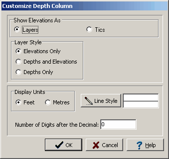
The style of the elevation column can be changed using the Customize button on the Columns tab. When the Customize button is pressed the Customize Elevation Column form will be displayed.
(The appearance of the form will differ slightly depending on if it is WinLoG or WinLoG RT)
The Customize Elevation Column form can be used to set the following parameters:
Show Elevations As: Elevations can be displayed as “layers” or “tics”. If “layers” is selected, a line will be drawn across the elevation column at each layer boundary and the elevation displayed. If “tics” is selected the elevation will be displayed at regular intervals similar to the depth column.
Layer Style: If the elevations are displayed as “layers”, the “elevation only” or “elevation and depth” can be displayed at each layer boundary. If the elevations are displayed as “tics”, this field will not appear.
Major Tic Interval: This is depth interval between labels on the elevation axis. If elevations are displayed as “layers” this field will not appear.
Minor Tic Interval: This is depth interval between tics on the elevation axis. If elevations are displayed as “layers” this field will not appear.
Display Units: This is the units to use to display the elevation column. The display units do not have to be the same as input units.
Line Style: This is the line style to use when drawing the layer boundaries or tics in the elevation column. When the Line Style button is pressed, a Line Properties form will be displayed. This form can be used to set the line style, width, and color.
Number of Digits after the Decimal: This is the number of digits to display after the decimal in the labels. For example, if the number of digits is 1, then the elevation 101 feet will be labeled as 101.0.