|
<< Click to Display Table of Contents >> Depths and Elevations |
  
|
|
<< Click to Display Table of Contents >> Depths and Elevations |
|
Before entering any depth related log data, the boring/well depth should be entered. There is no limit to the depth of a log. The depth entered must be in the same units as the input units for the template.
The depth and elevation parameters of the borehole log can be edited by:
•clicking on the depth or elevation column on the log
•double click on the Depth object on the sidebar
•select Edit > Depths & Elevations
•or select Popup > Depths & Elevations
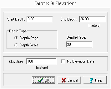
After this the form below will be displayed.
(The appearance of the form will differ slightly depending on if it is WinLoG or WinLoG RT)
The following information can be edited on this form:
Start Depth: This is the start depth, normally equal to 0 for ground surface. If you would like to show an aboveground well cover or “stick- up”, enter a negative number.
End Depth: This is the bottom depth. There is no limit to the depth of the borehole.
Depth Type: The depth per page specified in the template normally determines the plot depth per page; however, this can be overridden in the log by specifying a depth per page here. This feature allows you to change plot depths per page without changing the template. The depth per page can be overridden by either specifying a new depth/page or a new depth scale. To accept the default template plot depth per page, specify the plot depth per page as zero when editing the log.
Depth/Page: If the Depth Type is Depth/Page the new depth per page can be entered.
Depth Scale: If the Depth Type is Depth Scale the new depth scale can be entered.
Elevation: The elevation of the boring/well at ground surface.
No Elevation Data: If checked only the depths at each layer boundary will be shown. Otherwise, both the depth and elevation will be shown at each layer boundary.