|
<< Click to Display Table of Contents >> Importing an Excel Deviation Survey |
  
|
|
<< Click to Display Table of Contents >> Importing an Excel Deviation Survey |
|
To import a deviation survey from an Excel file select File > Import > Deviation Survey > Excel File, the Import Excel Deviation Survey Form below will be displayed.
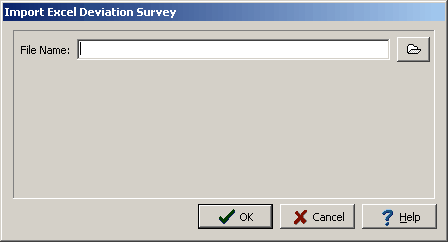
(The appearance of the form will differ slightly depending on if it is WinLoG or WinLoG RT)
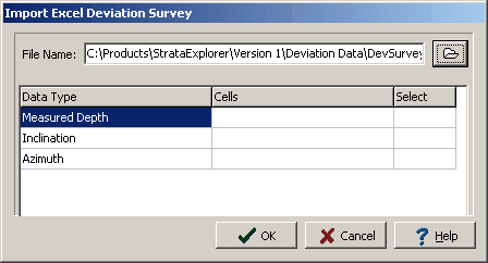
After the name of the Excel File is specified, the Import Excel Deviation Survey Form will contain a grid that contains three rows and three columns as shown below.
(The appearance of the form will differ slightly depending on if it is WinLoG or WinLoG RT)
The Row Headers are:
Measured Depth: The measured depth at which a deviation survey reading was taken.
Inclination: This is the dip of the borehole from true vertical. The angle is measured from the vertical, so that an angle of 0 represents vertical.
Azimuth: The azimuth angle is the compass bearing, relative to true (geographic) north, of a point on the horizon directly beneath an observed object. The horizon is defined as a huge, imaginary circle centered on the observer, equidistant from the zenith (point straight overhead).
The Column Headers are:
Data Type: The data type to be stored in a cell.
Cells: The cells chosen from the spread sheet for a data type. In general you should choose the same number of cells for the measured Depth, as you do for the Inclination and azimuth.
Select: Clicking the select column once shows the Select button for that row. Double clicking it opens up the Excel Spread sheet from which you can select the deviated survey data.
To add Measured Depth data double click the first row in the select column. This will open the excel file, select the cells you wish to use for the measured depth data then right click the mouse.Repeat this process for the inclination and azimuth. Finally click the OK button to process the data.