|
<< Click to Display Table of Contents >> Boundary Tab |
  
|
|
<< Click to Display Table of Contents >> Boundary Tab |
|
This tab is shown for georeferenced projects only and used to specify the georeferenced boundary points.
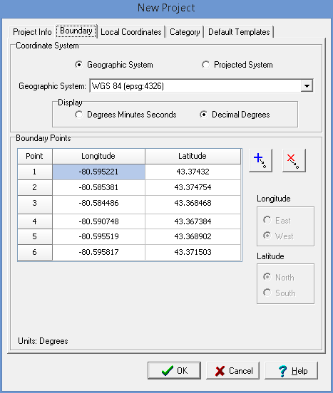
(The appearance of the form will differ slightly depending on if it is WinLoG or WinLoG RT)
The default coordinate system for georeferenced projects is the WGS 84 geographic system. Alternate geographic or projected coordinate systems can be selected; however, the coordinates stored in the database will be in the default system.
Coordinate System
Geographic System: Select this to specify the boundary in geographic coordinates.
Projected System: Select this to specify the boundary in projected coordinates.
Coordinate System: This is used to select the geographic or projected coordinate system.
Degrees Minutes Seconds: If the selected coordinate system is geographic, select this to specify the coordinates as degrees, minutes, and seconds.
Decimal Degrees: If the selected coordinate system is geographic, select this to specify the coordinates in decimal degrees.
Boundary Points
Longitude: If it is a geographic coordinate system, this is the longitude of the boundary point in either decimal degrees or degrees, minutes, and seconds.
Latitude: If it is a geographic coordinate system, this is the latitude of the boundary point in either decimal degrees or degrees, minutes, and seconds.
X Coordinates: If it is a projected coordinate system, this is the x coordinate of the boundary point.
Y Coordinates: If it is a projected coordinate system, this is the y coordinate of the boundary point.
Add Point: Press this button to add a point to the boundary.
Delete Point: Press this button to delete the selected boundary point.