|
<< Click to Display Table of Contents >> Geotechnical Data |
  
|
|
<< Click to Display Table of Contents >> Geotechnical Data |
|
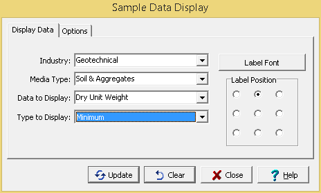
The following can be entered on the Display Data tab:
Industry: This is used to select the industry type for the data. It can be either environmental or geotechnical.
Media Type: This is used to select the media type to display. It can be either soil & aggregates, rock, concrete or asphalt.
Data to Display: This is used to select the sample data to show on the map. The sample data that can be selected will depend on the industry.
Type to Display: This is used to select which data to display at each station location when there is more than one sample for a station. It can be either the maximum, minimum, average, most recent or oldest.
Label Font: This is used to select the font to use for the labels.
Label Position: The label can be positioned around the sample by selecting the position relative to the center of the sample.
The Options tab shown will depend on the media type. If the media type is soil & aggregates, rock, or asphalt the tab below will be shown.
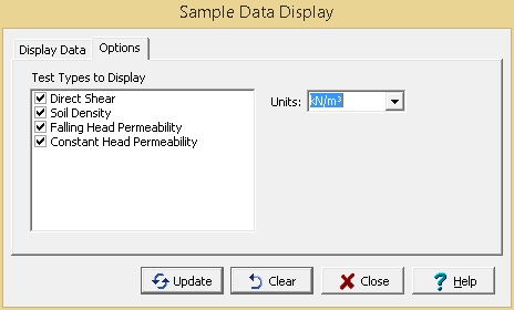
The following can be specified on this tab:
Test Types to Display: This is a list of test types that contain results for the selected data to display. Check the test type to display it on the map.
Units: This is used to select the units for the test results. If Original is selected the units used will be the original units of the test, this may result in some of the data being displayed in different units.
If the media type is concrete the tab below will be shown.
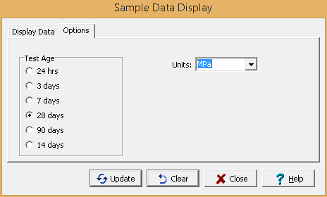
The following can be specified on this tab:
Test Age: This is used to select the concrete test age for the results to be displayed on the map.
Units: This is used to select the units for the test results. If Original is selected the units used will be the original units of the test, this may result in some of the data being displayed in different units.