|
<< Click to Display Table of Contents >> Georeferencing to a Point |
  
|
|
<< Click to Display Table of Contents >> Georeferencing to a Point |
|
If the project is to be georeferenced to a point on the map you will then need to click on the basemap at one of the corners of the project. After this the Georeference Project form below will be displayed.
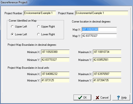
(The appearance of the form will differ slightly depending on if it is WinLoG or WinLoG RT)
The following information can be specified on this form:
Corner Identified on Map: This is the corner of the project that was used to identify the location on the basemap.
Map X: This is the X location, normally longitude, for the corner on the basemap.
Map Y: This is the Y location, normally latitude, for the corner on the basemap.
Local Project Units: This is the local units for the project. If the project has already been georeferenced and is only being re-positioned this will not appear.
The following information can be viewed on this form:
Project Number: This is the project number.
Project Name: This is the project name.
Project Map Boundaries: These are the project's boundaries on the basemap in map and local units. These boundaries will change as the corner identified on the map is changed.