|
<< Click to Display Table of Contents >> Editing a Stratigraphic Framework |
  
|
|
<< Click to Display Table of Contents >> Editing a Stratigraphic Framework |
|
After a stratigraphic framework has been created or opened it can be edited on the Stratigraphic Framework form. This form lists the dataset currently in the stratigraphic framework. There are two steps to the creation and editing of a stratigraphic framework, adding the datasets and specifying the grids. The Back and Next buttons at the bottom of the form are used to move from one step to the other.
Specifying the Datasets
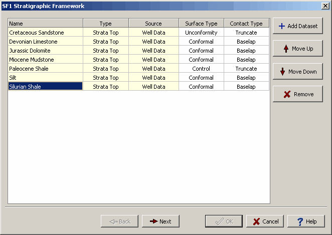
The buttons on the side of the form can be used for the following:
Add Dataset: This button is used to add datasets as described in the section below on adding datasets.
Move Up: This button will move the selected dataset up one in the list.
Move Down: This button will move the selected dataset down one in the list.
Remove: This button will remove the selected dataset from the list.
For each dataset in the list the following can be displayed or edited:
Name: This is the name of the dataset. This field is filled in when the dataset is added and can not be edited.
Type: This is the type of dataset. This field is filled in when the dataset is added and can not be edited.
Source: This is the source of the dataset. This field is filled in when the dataset is added and can not be edited.
Surface Type: This is the type of surface the dataset represents. The surface can be either conformal, control, non-conformal, special or unconformity.
Contact Type: This is the type of contact the dataset makes with the dataset below. The contact an either be truncate or baselap.
The types of surface and contacts are explained in the section on stratigraphic frameworks. After the datasets have been specified, click the Next button to specify the grids.
Specifying the Grids
After the Next button has been pressed the form will change to show the grids in the stratigraphic framework. For each dataset added in the previous step a grid will be created. The Edit Grid Info button on the side is used to specify the gridding parameters as discussed in the section below. All of the grids will use the same gridding parameters.
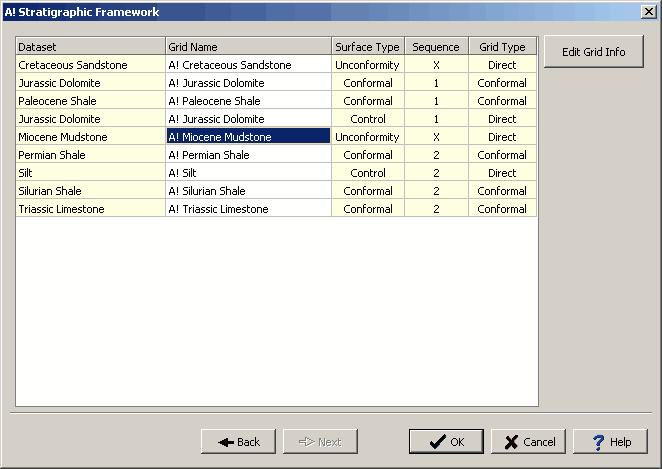
The following can be edited for each of the grids in the list:
Dataset: This is the name of the dataset that is being gridded. Each dataset added in the previous step will be added to the list of grids. This field can not be edited.
Grid Name: This is the name of the grid. The name is filled in by the program and can be edited.
Surface Type: This is the surface type for the dataset that was specified in the previous step.
Sequence: This is the sequence for the grid. Unconformities are given a sequence of "X" and will start a new sequence below them.
Grid Type: This is the type of grid, it can be either direct or conformal. If the type of surface is conformal the grid type will be conformal. All other types of surface will have a direct grid type.
After the gridding information has been specified, click the Ok button to create the stratigraphic framework.