|
<< Click to Display Table of Contents >> Grid Information Tab |
  
|
|
<< Click to Display Table of Contents >> Grid Information Tab |
|
The first tab on the Grid form is for the Grid Information.
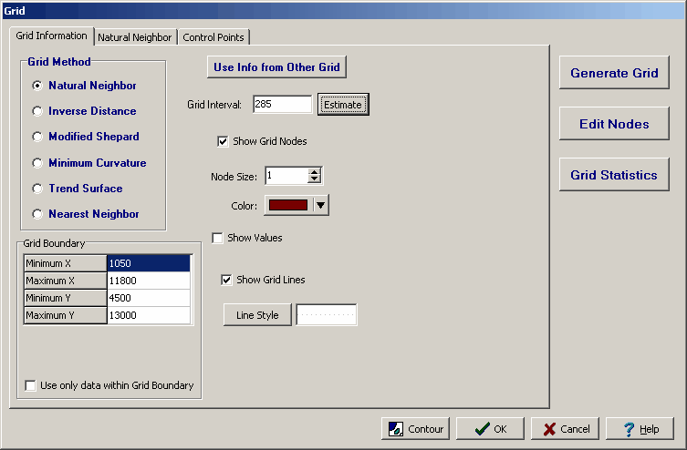
The following information can be edited on this tab:
Grid Method: This is used to select the gridding algorithm. Depending on the algorithm selected an additional tab will appear on the form for additional grid parameters.
Grid Boundary: This is the boundary of the grid. If the grid boundary is a rectangle it will be the horizontal and vertical boundaries of the rectangle. If the grid boundary is a polygon it will be the points defining the polygon.
Use only data within the Grid Boundary: Check this box to use only the data within the boundary of the grid. Otherwise, all of the data in the map will be used to calculate the grid.
Use Info from Other Grid: Click this button to use the information defined in another grid in the project. A list of existing grids will be displayed to select the grid. This is useful to create a series of maps all using the same gridding parameters.
Grid Interval: This is the horizontal and vertical interval between grid nodes. The interval can be estimated by the program by clicking on the Estimate button.
Show Grid Nodes: Check this box to show the grid nodes as small circles on the map.
Node Size: This is the size of the small circles used to display the grid nodes. If the grid nodes are not being shown this field will not appear.
Node Color: This is the color of the small circles used to display the grid nodes. Click the button to display a Color form and select the color. If the grid nodes are not being shown this field will not appear.
Show Values: Check box to show the values of the grid nodes on the map.
Value Font: Click this button to change the font used to display the value of the grid nodes. If the values are not being shown this field will not appear.
Show Grid Lines: Check this box to display grid lines on the map.
Line Style: Click this button to change the line style of the grid lines. A Line Properties form will be displayed where the style, color, and width of the lines can be selected. If the grid lines are not being shown this field will not appear.