|
<< Click to Display Table of Contents >> Location Map |
  
|
|
<< Click to Display Table of Contents >> Location Map |
|
The location map is a bitmap representation of the project map and can be shown anywhere on a template. To edit the location map either:
•select Edit > Location Map
•select Popup > Location Map
•double-click on the location map on the template
(The appearance of the form will differ slightly depending on if it is WinLoG or WinLoG RT)
This form can be used to edit the following information:
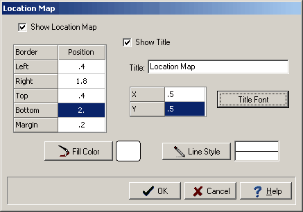
Show Location Map: Check this box to show the location map on the template.
Left Position: This is the horizontal position of the left boundary of the location map.
Right Position: This is the horizontal position of the right boundary of the location map.
Top Position: This is the vertical position of the top boundary of the location map.
Bottom Position: This is the vertical position of the bottom boundary of the location map.
Margin: This is the margin between the location map and the frame.
Show Title: Check this box to show the title on the location map.
X: This is the horizontal position of the title.
Y: This is the vertical position of the title.
Title Font: Click this button to change the font for the title.
Fill Color: Click this button to change the fill color.
Line Style: Click this button to change the line style of the frame around the location map.