|
<< Click to Display Table of Contents >> Information |
  
|
|
<< Click to Display Table of Contents >> Information |
|
(The appearance of the form will differ slightly depending on if it is WinLoG or WinLoG RT)
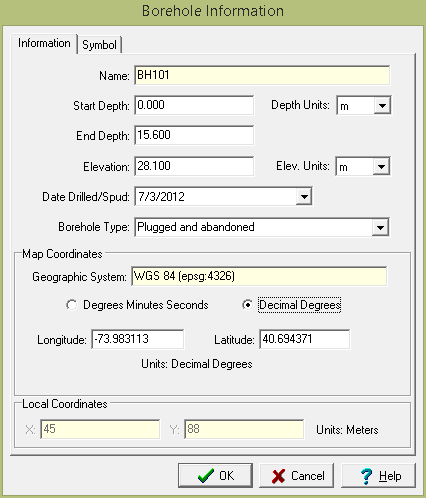
The following information can be specified on this tab:
Unique Boring/Well ID: If the module type is Oil & Gas, this is the unique ID for the boring/well.Otherwise, this is not displayed. The Unique ID can not be edited after the boring//well log has been created.
Name: This is the name of the boring/well. The Name can not be edited after the boring//well log has been created.
Start Depth: This is the start depth. To indicate an aboveground boring/well completion a negative value can be entered.
End Depth: This is the end depth.
Depth Units: These are the units for the depths.
Elevation: This is the elevation of the ground surface of the boring/well.
Elevation Units: These are the units for the elevation.
Spud Date: This is the date drilling started.
Well/Borehole Type: This is the type of the boring/well.
Map Coordinates
If it is a local project the following are not displayed.
Coordinate System: This is the coordinate system specified when the project is created. It can be either a geographic or projected coordinate system. The default is the WGS 1984 geographic coordinate system used internally by the program to store location data.
Degrees Minutes Seconds or Decimal Degrees: If the coordinate system is geographic, this can be used to display the coordinates in either degrees, minutes, and seconds or decimal degrees.
Longitude: For a geographic coordinate system this is the longitude in either degrees, minutes, and seconds or decimal degrees.
Latitude: For a geographic coordinate system this is the latitude in either degrees, minutes, and seconds or decimal degrees.
Easting: For a projected coordinate system this is the x coordinate in map units.
Northing: For a projected coordinate system this is the y coordinate in map units.
Local Coordinates
Local X-Coordinate: This is the x coordinate in local units. If the project is georeferenced the local coordinates are calculated automatically.
Local Y-Coordinate: This is the y coordinate in local units. If the project is georeferenced the local coordinates are calculated automatically