|
<< Click to Display Table of Contents >> Layer Tab |
  
|
|
<< Click to Display Table of Contents >> Layer Tab |
|
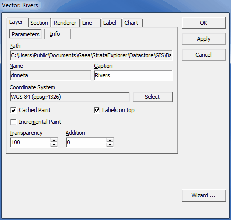
This tab is displayed for both vector and raster layers and has two sub-tabs. The following information can be entered.
Parameters
Path: [READ ONLY] Path to the file containing the layer. |
Name: [READ ONLY] Name of the file containing the layer. |
Caption: Name under which it appears in the Legend panel. |
Coordinate System: Coordinate system in which the layer is displayed. |
Cached Paint: If unchecked, the rendering is performed directly on the Map area, which can dramatically improve performance with very large and complicated vector data sets but causes Map area flickering. |
Labels on top: If checked, labels are displayed on top of all layers in the project. |
Incremental paint: If unchecked, the rendering in Drag mode is performed only after the mouse button is released, which can dramatically improve performance with very large and complicated vector data sets. |
Transparency: Factor defining the layer transparency; it must be greater or equal to 0 and lower or equal to 100, where 0 means invisible and 100 means opaque. |
Addition: Factor determining the degree to which the background color of the layer is added to the color of the layer shapes; it must be greater or equal to 0 and lower or equal to 100, where 0 means shape color and 100 means layer background color; this feature applies only to anaglyph images.
|
Info
File information: [READ ONLY] Information about the file format. |
User comments: Additional information provided by the user/file creator. |
From Codepage: Codepage to be used for reading layer parameters. |
To Codepage: Codepage to be used for processing/displaying layer parameters.
|